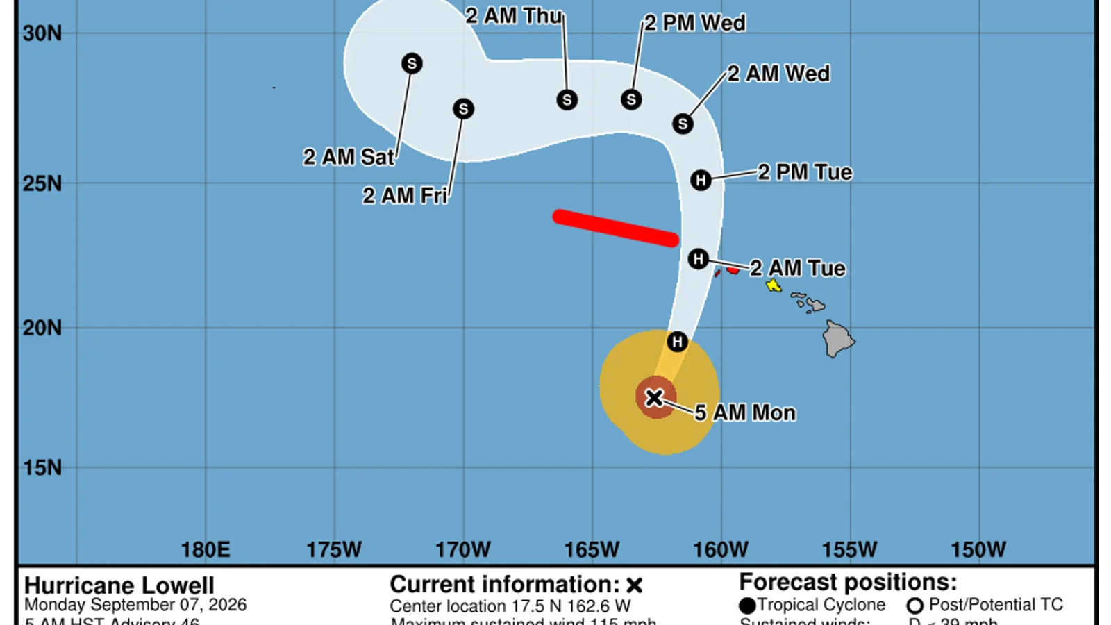
Status at 15:00 UTC
Hurricane Lowell was centred near 17.5°N, 162.6°W at 15:00 UTC on Monday, 7 September. The National Hurricane Center placed the centre about 600 kilometres southwest of Lihue and 650 kilometres southwest of Honolulu. Maximum sustained winds were 185 km/h, with the hurricane moving north-northeast at 22 km/h. The estimated central pressure was 950 hPa.
Those figures describe the official analysis at one advisory time. They are not live measurements for every island, and they will change as new aircraft, satellite and surface observations arrive. The timestamp matters as much as the number.
Warnings and watches
The 05:00 HST public advisory had a Hurricane Warning in effect for Kauai County, including Kauai and Niihau. A Tropical Storm Watch was issued for Oahu. A warning means hurricane conditions are expected somewhere within the warning area; a watch means tropical-storm conditions are possible within the watch area. Readers in Hawaii should use the latest Central Pacific Hurricane Center bulletin and instructions from local emergency officials, because this article is a timed summary rather than an alert service.
Lowell’s centre was still well southwest of the islands, but impacts do not stop at the centre point. Wind fields, rain bands and ocean swell cover a much broader area. The forecast cone only represents the probable track of the cyclone’s centre. It does not mark a safe boundary.
What the track forecast showed
The 15:00 UTC forecast advisory carried Lowell northward during the next day and then gradually westward farther north of Hawaii. The intensity forecast called for slow weakening, from 100 knots at the advisory time to 95 knots at 00:00 UTC Tuesday and 90 knots at 12:00 UTC Tuesday. Forecast position and intensity errors grow with time, so an exact line through the cone should not be read as a promise.
This is why the warning area and local forecast matter more than the centre line. A small east or west shift can change which locations see the strongest wind or heaviest rain, while large swells may arrive far from the core.
What to check next
For a quick update, compare three things in the next official advisory: the position of the centre, the extent of the warning area and any change in the forecast track near the islands. Then read the local National Weather Service forecast for your island. Travellers should also check airlines and harbour operators directly.
Do not use a general city forecast as a substitute for a tropical cyclone warning. Our city pages show numerical model estimates; the Central Pacific Hurricane Center combines specialist analysis, observations and hazard messaging for this storm.